
| Import Geometry | |
You can either import transect data or an ESRI Shapefile.
When importing an ESRI Shapefile and no associated *.prj is found, you will be asked to define the Coordinate Reference System (CRS) on which is coordinates of the shapefile are defined.
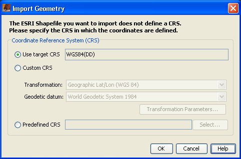
You can choose between three options to define the CRS:
If transect data is imported it is converted into a geometric shape defined either in pixel or geodetic (WGS-84) co-ordinates from a text file.
Transect data files are text files and have the default extension .txt. Each line in the file
corresponds to a single vertex point of the geometric shape. Co-ordinates are stored in columns separated
by whitespace characters (space or tabulator). All co-ordinates refer to a pixel's upper left
corner. A file can have a header line in order to specify column names.
Columns 1 and 2 are mandatory and contain the point's pixel X co-ordinate and Y co-ordinate, respectively. Columns 3 and 4 are optional and contain the point's geodetic latitude and longitude co-ordinates defined on the WGS-84 ellipsoid in decimal degree. Other columns are ignored:
column 1: mandatory X co-ordinate given in pixels column 2: mandatory Y co-ordinate given in pixels column 3: optional latitude in decimal degree column 4: optional longitude in decimal degree column 4 + i: optional additional data
If the current product is geo-coded, which is always true for ENVISAT products or map projected products, and the geodetic co-ordinates are given, the pixel co-ordinates are rejected. In this case, VISAT computes the actual pixel co-ordinates for the current product.
For example (note, 5th column is ignored):
        207 390 43.167255 -7.7339296 38.732
        208 389 43.175785 -7.718502 48.529
        208 388 43.18614 -7.715622 50.889
        209 387 43.19465 -7.7002006 38.709
        ...
The file can optionally contain a header line. The header line contains column names which are also expected to be separated by whitespace characters. Some column names have a special meaning for the import command, since they specify the alternate column for the recognized co-ordinates. Special names can appear in any order and are letter case insensitive. They are:
x,pixel_xorpixel-x:X co-ordinate given in pixels y,pixel_yorpixel-y:Y co-ordinate given in pixels latorlatitude:latitude in decimal degree lon,longorlongitude:latitude in decimal degree other names: ignored
Either pixel or geodetic co-ordinates must be given. Again, if geodetic co-ordinates are present, they override the point's pixel co-ordinate if present, since they are recomputed by VISAT. The columns can appear in any order.
For example (note, columns named "Index" and "radiance_11" are ignored):
        Index Pixel-X Pixel-Y Lat Lon radiance_11
        0 205 393 43.139843 -7.767645 35.16
        1 206 392 43.148373 -7.752228 32.764
        2 206 391 43.158722 -7.749352 35.751
        ...